Aids to Navigation (ATONs) are signs and markers that assist boaters in navigation. In the waters near Marco Island, these are primarily daymarkers (red and green signs that mark waterway channels). The majority of ATONs near Marco Island are owned and maintained by the County or City and are often referred to as PATONs (Private ATONs) as opposed Federally owned ATONs which are maintained by the Coast Guard (USCG). On this page, we refer to all of them as "ATONs".
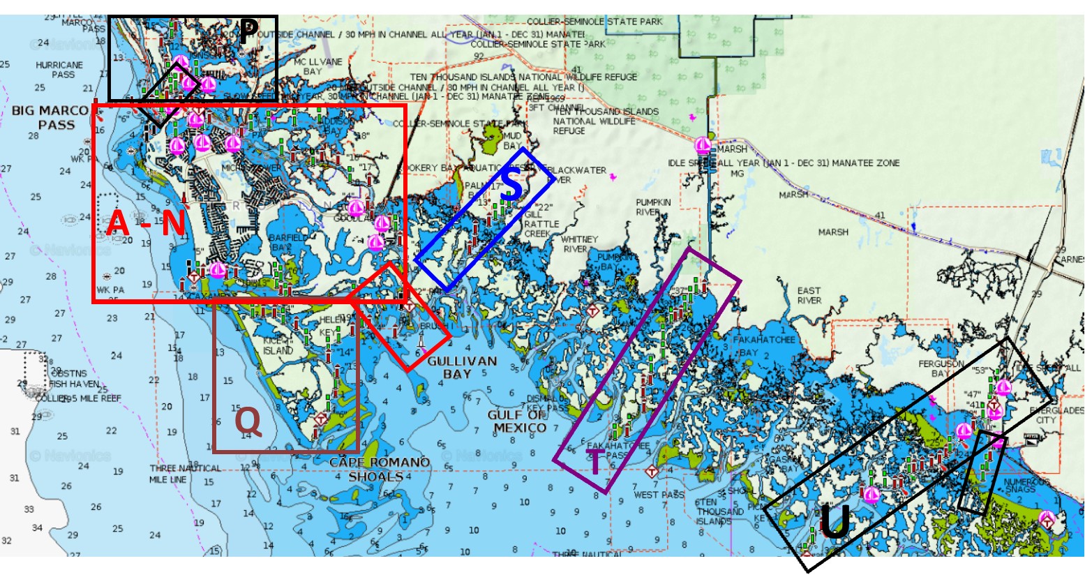
As part of the United States Power Squadron's Cooperative Charting Program, members of our local squadron conduct surveys of ATONs in the vicinity of Marco Island (from Everglade City to about one mile north of Marco Island). During a survey, we photograph each ATON and record coordinates of it's location and notes on it's condition. We use this data as follows:
1. We report details about damaged and missing ATONs to government organizations that are responsible for maintaining them. In the vicinity of Marco Island, most ATONs are maintained by the Collier County Coastal Zone Management organization (CZM); we meet periodically with leaders of CZM.
2. We compare our data to information published in nautical charts and report discrepancies to government agencies responsible for maintaining the charts.
3. We publish the data on this website in three formats: KML file for viewing survey data in Google Earth or ArcGIS, Excel file that displays the information in Tables, and Photos of the ATONs. A link to each format is provided below.
____________________________________________________________
 This link downloads a KMZ file to the default download directory of your computer. When this file is opened in Google Earth or ArcGIS, icons representing ATONs are plotted on a satellite image of the Marco Island area. Google Earth Pro and ArcGIS Earth are free programs available for Windows, Apple and Android devices. When the KML file is opened in one of these apps, a rectangular icon "Icon Key" is visible to the west of Marco Island; clicking on this icon displays a definition of the various icons. Clicking on a survey icon brings up a balloon showing additional information, including condition, owner and photo of the ATON. (In ArcGIS and mobile Google Earth apps, the photo is not displayed by default, but can be viewed by clicking the photo icon or link. In Google Earth mobile Android app, photos and details do not display unles the kml file is imported as a project rather than just opened as a file.) Light list icons and various categories of the Light-list and Survey data can be turned on or off by expanding the folders and checking or un-checking boxes in the Places panel on the left side of the Google Earth or ArcGIS window (note: this additional data is currently not available on mobile apps for Google Earth). If the folder "MISPS ATONs" is moved from "Temporary Places" to "My Places", it will be there the next time you open Google Earth and the display will automatically update to the most recent survey information when you open Google Earth in the future. More details - installing and using Google Earth to view ATON data.
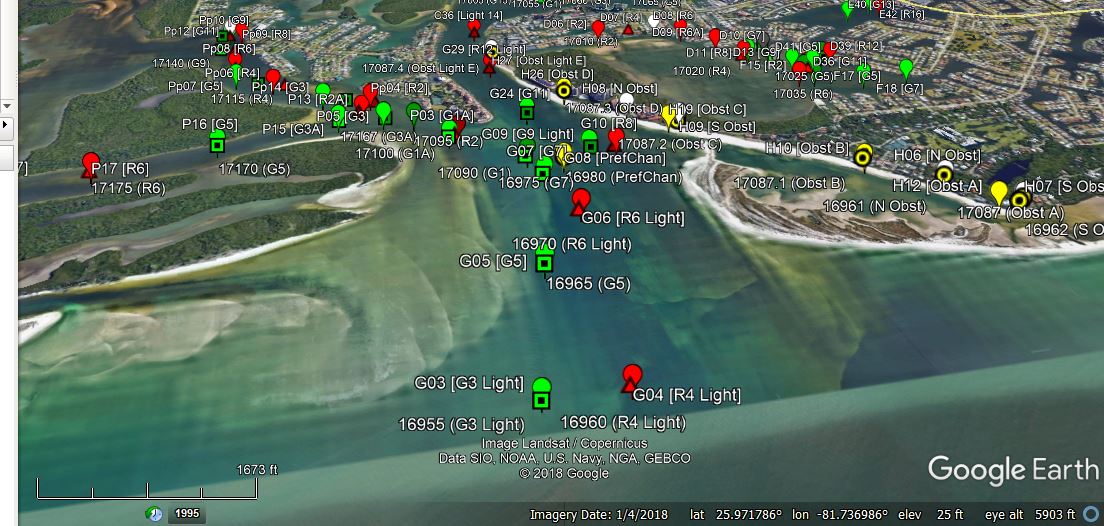
Screen capture from Google Earth: Capri Pass showing actual ATONs and light list ATONs
____________________________________________________________
 This link takes you directly to a display of the ATON survey data in Google Maps. Clicking an icon in the display brings up additional information about the ATON. On a phone or tablet you may need to tap a second link to see the photo and details. The display is similar to viewing the KML file in Google Earth, but does not display photos as well, does not display coordinates, and lacks other features available in Google Earth.
____________________________________________________________
 This link downloads an Excel Workbook to your computer. The workbook has multiple sheets, each with different sets of information. The first sheet, "1. Description", lists the other sheets with a description of each. Sheet "2. Survey Data" lists all available survey data for each ATON going back to our first survey in 2006. Sheet "3. Most Recent Data" has only the most recent data on each ATON; the KMZ file for Google Earth uses data from this sheet, including condition, owner and link to a photo. Most of the data is from on-the-water surveys by MISPS members, but the file also contains data provided by United States Coast Guard Auxiliary (USCGA) members and Collier County Costal Zone Management (CZM) employees. More details - downloading and viewing the Excel file.
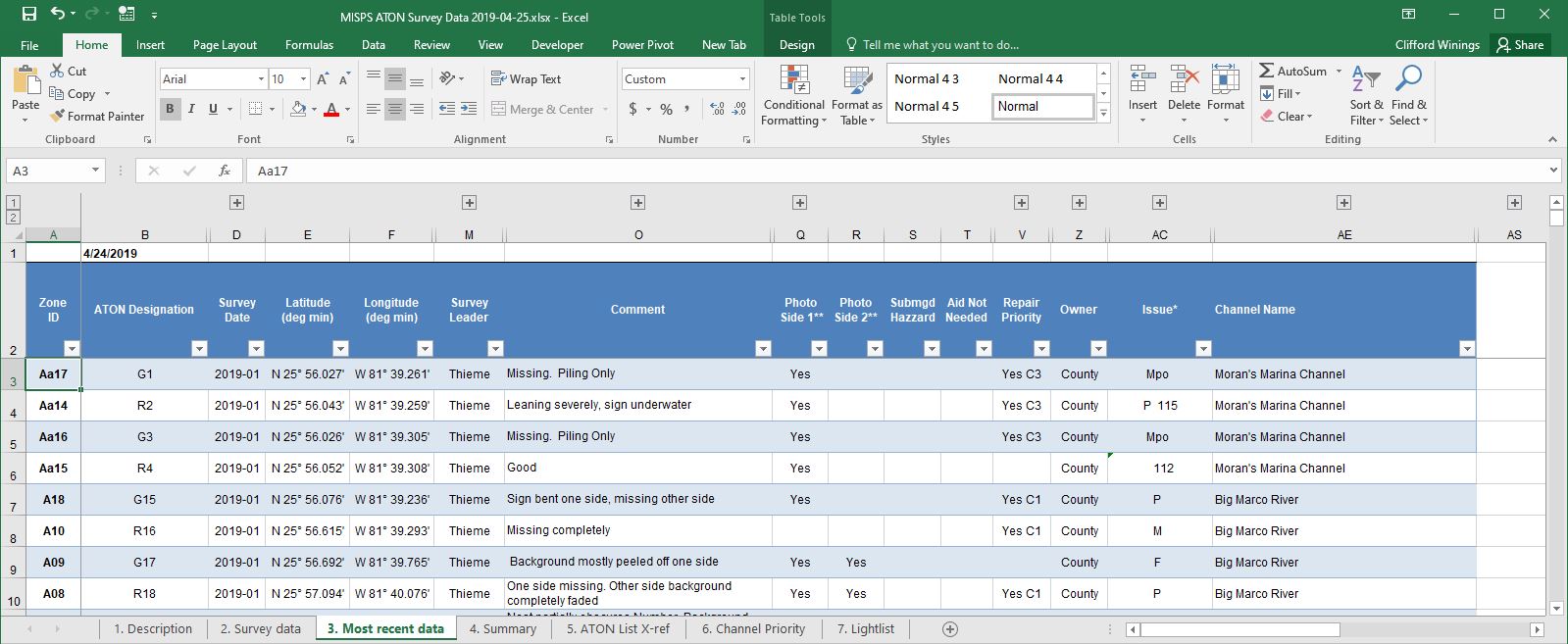
Screen capture from Excel: portion of table listing ATON data
____________________________________________________________
 This link opens a directory of photo folders in Google Drive listed by Zone ID and channel name. Within each of these folders, subfolders are listed by date going back as many as 20 years. To read full folder names, use List view rather than Grid view (icon at upper right in the Google Drive window). Most photos are in folders, but some are in PDF documents. The individual photo folders are best viewed in Grid view, where thumbnails of the photos are visible. Most of the recent photos are taken using smartphone apps that show location coordinates and shooting direction on the photo. The Excel file and KML display contain direct links to many of these photos. More details - viewing the photos.
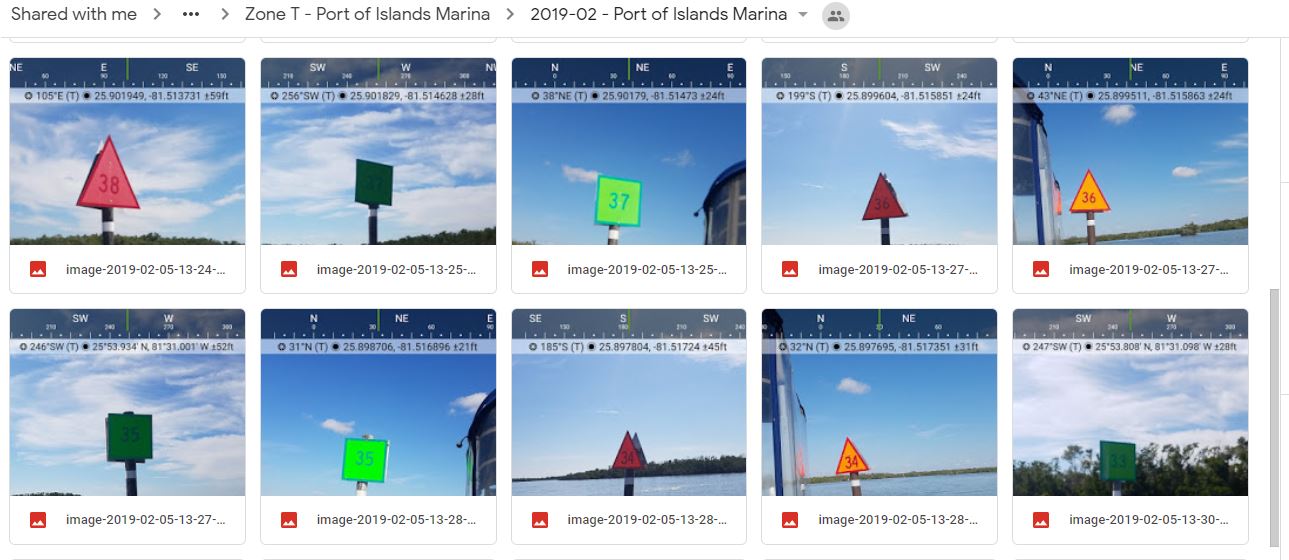
Screen capture from Google Drive: thumbnails of photos in a waterway on a specific date